Synopsis:
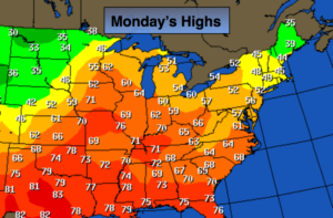
The start of the workweek will be decent as high pressure slips offshore. A mix of sun and clouds is expected with above average readings. The average high is 47º. There still remains no arctic air in the country. The map above depicts just how warm the nation is. A sharp front is beginning to show it’s colors over the Northern plains. This front will move toward the region on Tuesday and Tuesday night with scattered showers and warm temperatures. We may flirt with 60º on Tuesday.
The computer models have now sped up the speed of the front so it looks like Wednesday morning will be rain free with the exception of showers over Eastern sections early in the morning. Skies will clear and temperatures will drop during the afternoon. This will be the start of the major pattern change to colder that will take hold for some time to come. Will a storm form along the Eastern Seaboard? At this time the models have a system well off the coast Friday Night and Saturday. We need to monitor the latest guidance as any shift to the West could result in a snowfall.
Stay tuned.
Today:
Patchy AM Fog, otherwise partly sunny and mild. Highs in the lower 50s. Northeast to Southeast winds at 5-10mph.
Tonight:
Mostly cloudy and mild. Lows in the mid to upper 40s in the City, near 40º inland. Southeast winds at 5-10mph.
Tuesday:
Cloudy with scattered showers and areas of drizzle. Much warmer. Highs in the upper 50s.
Wednesday:
Early Clouds and showers East giving way to mostly sunny skies. Highs around 50º early, then readings will fall through the 40s.
Thursday:
Partly sunny, colder. Highs in the lower 40s.
Friday:
Sun to clouds. Highs around 40º.
Keep it here for a no nonsense, no hype forecast.