Synopsis:
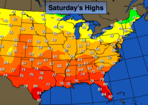
The first weekend of December will be a gentle one as high pressure dominates. There still remains no arctic air in the country. Take a look at the map above-unseasonably mild from coast to coast. The jet stream remains zonal (from East to West) and is not allowing the Canadian air into the nation. The sun will dominate through the weekend and into Monday.
A major pattern change looks to be on the way for midweek next week. Much colder air will spill into the area. Before the transition, a warm Southerly flow ahead of the cold front will occur on Tuesday and Wednesday. A few showers are possible later Tuesday with periods of rain expected Tuesday night and Wednesday. Then it will turn much colder.
The long range models have the cold air sticking around. Will a storm form along the Eastern Seaboard in the next two weeks?
Stay tuned.
Today:
Sunny. Highs in the upper 40s. Light East to Southeast wind under 5mph.
Tonight:
Partly Cloudy. Lows in the upper 30s in the City. The 20’s to around freezing inland. Light and variable winds.
Sunday:
Sunny. Highs near 50º.
Monday:
Sunny. Highs near 50º.
Tuesday:
Mostly cloudy. Much warmer. Chance of late day showers. Highs in the mid to upper 50s.
Wednesday:
Mostly cloudy and warm with periods of rain. Highs in the mid to upper 50s.
Keep it here for a no nonsense, no hype forecast.