Synopsis:
Brief Isolated showers or thunderstorms are possible this evening as a disturbance moves through. Most areas will remain dry.
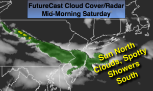
The first weekend of June will be fairly decent. It’ll be bookended by a shower threat but the majority of the time will be dry. Saturday morning will feature a rapidly moving area of clouds and showers associated with a weak trough of low pressure. The clouds and showers will affect areas to the South of the City (FutureCast Cloud Cover & Radar above). If you have an rain Saturday morning will only last a couple of hours. Farther to the North the morning hours will be mainly sunny. All areas will experience sunshine and seasonal readings by mid-day and afternoon. It’ll be a gem. Sunday will start off with some sun but scattered showers and thunderstorms will work in by mid-afternoon as an area of low pressure begins to affect the region from the Great Lakes. The forecast for Sunday is more optimistic.
Unsettled times will be with us for the beginning of the workweek.
Stay tuned.
Tonight:
A spot shower or storm early this evening , otherwise mostly clear. Lows in the mid to upper 50s in the City, the 40s to lower 50s inland. Northwest winds diminishing to 5-10mph.
Saturday:
Early morning clouds and scattered showers South of the City otherwise mostly sunny and pleasant. Highs in the mid 70s.
Sunday:
Sun to clouds with scattered afternoon showers and thunderstorms. Highs in the mid 70s.
Monday:
Sun and clouds with scattered showers and thunderstorms during the afternoon. The morning looks dry . Highs in the mid 70s.
Tuesday:
Mostly cloudy with scattered showers. Very cool. Highs in the mid 60s.
Wednesday:
Sun and clouds with spotty showers. Cool. Highs in the upper 60s.
Keep it here for a no nonsense, no hype forecast.