Synopsis:
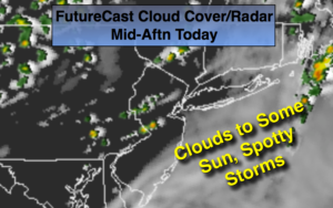
The large storm over Canada that has been pinwheeling disturbances our way has no plans of changing it’s plans through today. Morning clouds with areas of drizzle and fog. Some sun is possible during the afternoon. Scattered thunderstorms may fire up with the disturbance moving through in the afternoon and evening (FutureCast Radar above).
High pressure will move into the region Thursday. The sun will finally dominate. It now looks like Friday and Saturday will be pleasant with a mix of sun and clouds. Showers are possible Sunday.
Stay tuned.
Today:
Fog and spotty morning drizzle otherwise mainly cloudy (the sun may shine for a time this afternoon). A spot late day storm is possible. Warmer. Highs in the mid 70s. East to South wind at 5-10mph.
Tonight:
Spotty evening storms, otherwise partly cloudy. Lows around 60º in the City, the 50s inland. Southwest winds at 5mph.
Thursday:
Mostly sunny. Highs in the mid 70s.
Friday:
Partly sunny. An isolated late day storm is possible. Highs near 80º.
Saturday:
Partly sunny. Highs in the upper 70s.
Sunday:
Mostly cloudy with scattered showers. Highs in the lower 70s.
Keep it here for a no nonsense, no hype forecast.