Synopsis:
It will cloud up tonight with rain developing late as a warm front pushes North.
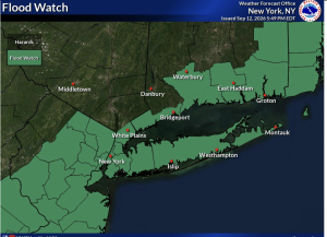
A Flood Watch is up for Sunday morning for most of the tri-state area. Areas of rain in the morning maybe torrential in spots. Flooding is a possibility. One to three inches of rain is possible by midday. If you encounter a flooded roadway- TURN AROUND-DON’T DROWN. You never know how deep that water is. There will be rapidly improving conditions midday through the afternoon as some sun is expected. It’ll be warm and humid.
Canadian high pressure will influence our weather for the beginning of the week. Mainly sunny skies are expected with slightly below average temperatures. It’ll be a Fall preview for sure!
Slightly warmer conditions are expected later in the week.
Stay tuned.
Keep it here for a no nonsense, no hype forecast….
Tonight:
Clouding up. Rain late. Lows in the 60s throughout. Southeast winds at 5mph.
Sunday:
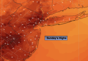
Scattered areas of morning rain with local downpours. Some afternoon sun. Warm and humid. Highs in the lower to mid 80s. S to Northwest winds at 5-10mph.
Monday:
Mostly sunny. Cooler and much less humid. Highs in the 70s.
Tuesday:
Sunny. Pleasant. Highs in the 70s.
Wednesday:
Mostly sunny. Highs around 80º.
Thursday:
Partly sunny. Highs around 80º.