Synopsis:
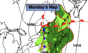
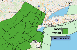
A strong Bermuda high in conjunction will low pressure to the West will create a deep Southerly flow today. A tropical airmass will be over region. Showers and storms are likely. The rain has the potential to be heavy at times in the morning. A Flood Watch has been issued for much of NJ through Monday. If you encounter flooded roadways: Turn around, don’t drown. The rain will taper off mid-morning. Scattered showers are possible during the afternoon.
Tuesday will feature high pressure over the region. Mainly sunny skies are expected along with pleasant temperatures.
The Bermuda high will re-establish itself from midweek on. The humidity will be the main story under a mix of sun and clouds. Afternoon showers are possible Wednesday and then again on Friday. Temperatures will get to just above average highs by late week.
Stay tuned.
Keep it here for a no nonsense, no hype forecast….
Monday:
Scattered showers and storms. Local downpours. Humid. Highs around 80º. Southwest winds at 8-15mph.
Tonight:
Spotty early shower, otherwise partly cloudy. Lows in the mid 60s in the City, the 50s inland. Light North wind.
Tuesday:
Mostly sunny. Highs in the lower 80s.
Wednesday:
Sun and clouds. Afternoon showers possible. Highs in the lower 80s.
Thursday:
Hazy. Humid. Highs in the upper 80s.
Friday:
Hazy. Humid. Scattered PM Storms. Highs in the upper 80s.