Synopsis:
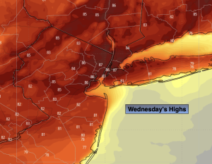
A weak cool front will approach the region today. More clouds than sun is expected. Spotty showers are possible from the City and to the South. It won’t be a washout. It’ll be warm with readings about ten degrees above the average high of the mid 70s.
High pressure will influence our weather from the Northwest Thursday and Friday. It’ll be bright with more seasonal readings.
The weekend will be a winner. Low pressure will move from Southeast Canada to off the New England coast. At the same time high pressure will build in from the Great Lakes. This will result in mainly sunny skies and pleasant readings. A nice change from last weekends misery.
Stay tuned.
Keep it here for a no nonsense, no hype forecast…
Wednesday:
More clouds than sun. Warm. Spotty shower South of the City. Highs in the mid 80s. West to Southwest winds at 8-12mph.
Tonight:
An isolated evening showers South, otherwise partly cloudy. Lows in the mid 60s in the City, the 50s elsewhere. Northwest winds at 5-10mph.
Thursday:
Mostly sunny. Pleasant. Highs in the upper 70s.
Friday:
Partly sunny. Seasonal. Highs in the mid 70s.
Saturday:
Partly sunny. Highs in the lower to mid 70s.
Sunday:
Mostly sunny. Highs in the lower to mid 70s.