Synopsis:
High pressure over Southeast Canada will keep us dry today. A mix of sun and clouds is expected. Readings will remain below the average highs of the lower to mid 7os.
Memorial Day Weekend still looks unsettled. Weak low pressure will remain to our South. This combined with strong high pressure over the Canadian maritimes will result in a raw flow off the ocean into Sunday. Periods of rain are likely Saturday. The rain could be heavy at times. On Sunday morning rain is likely. It should become more intermittent during the afternoon. At this time Memorial Day is featuring a mix of sun and clouds. A spot shower can’t be ruled out. Highs will be near average.
Tuesday will be the best of the bunch with sunny skies and warm readings as high pressure gains control.
Stay tuned.
Keep it here for a no nonsense, no hype forecast…
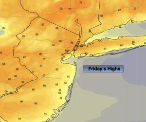
Friday:
Partly sunny Highs in the upper 60s. East winds at 8-15mph.
Tonight:
Becoming cloudy. Lows in the lower 50s in the City, the 40s inland. East winds at 5-10mph.
Saturday:
Periods of rain. Chilly. Highs only in the upper 50s.
Sunday:
Periods of rain. Highs in the lower to mid 60s.
Memorial Day:
Sun and clouds. Spot shower. Highs around 70º.
Tuesday:
Sunny. Warmer. Highs in the upper 70s.