Synopsis:
Low pressure will move across the region today. On an off showers are expected. It will not be a washout. In fact, there will be more dry times than wet. Temperatures will be several degrees below the average high of the lower 70s.
Friday should feature more sun, but an isolated shower can’t be ruled out behind the departing low.
A much warmer period is expected in the extended forecast as high pressure sets up shop off the Southeast coast. Saturday and Sunday will feature plenty of sun. Saturday’s highs will reach well into the 70s. Sunday’s highs will reach into the 80s.
It stays quite warm into the beginning of next week.
Stay tuned.
Keep it here for a no nonsense, no hype forecast…
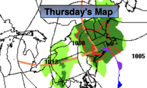
Thursday:
Mostly cloudy. Scattered showers possible. Highs in the mid 60s. North winds at 5mph.
Tonight:
Mostly cloudy. An isolated shower. Lows in the lower 50s in the City, the 40s inland. Northwest winds at 5-10mph.
Friday:
Partly sunny. An isolated shower. Highs in the mid 60s.
Saturday:
Partly sunny. Milder. Highs in the upper 70s.
Sunday:
Partly sunny. Warm. Highs in the lower to mid 80s.
Monday:
Partly sunny. Warm. Highs in the mid 80s.