Synopsis:
The next couple of days will feature low pressure near the region. A mix of clouds and some sun is expected for Wednesday. Temperatures will be near the seasonal averages of around 70º. It now looks like showers will hold off until evening. The shower threat will continue into Thursday as the system moves offshore. It will not be a washout.
Friday should feature more sun, but a spotty shower can’t be ruled out behind the departing low.
A much warmer period is expected in the extended forecast as high pressure sets up shop off the Southeast coast. Saturday and Sunday will feature plenty of sun. Saturday’s highs will reach well into the 70s. Sunday’s highs will reach into the 80s.
It stays quite warm into the beginning of next week.
Stay tuned.
Keep it here for a no nonsense, no hype forecast…
Tonight:
Partly cloudy. Lows in the lower to mid 50s in the City, the 40s inland. South winds at 5-10mph.
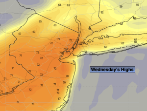
Wednesday:
Clouds and sun. Mild and breezy. Highs in the lower 70s.
Thursday:
Mostly cloudy. Scattered showers possible. Highs in the mid 60s.
Friday:
Partly sunny. Spotty afternoon shower. Highs in the mid to upper 60s.
Saturday:
Partly sunny. Milder. Highs in the mid to upper 70s.
Sunday:
Partly sunny. Warm. Highs in the lower to mid 80s.