Synopsis:
High pressure will influence our weather today and Tuesday. It will be pleasant with temperatures several degrees below the average high of 70º.
Midweek will feature a cool front approaching the region. Any sun Wednesday will give way to clouds and possible afternoon showers. The shower threat will continue into a part of Thursday as the system moves offshore. Below average temperatures will continue.
Friday will be bright and milder behind the departing low.
Stay tuned.
Keep it here for a no nonsense, no hype forecast…
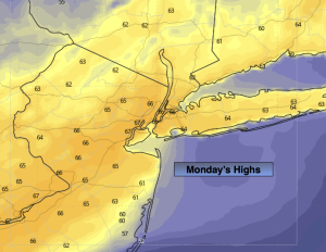
Monday:
Sun and clouds. Highs in the mid 60s. North winds at 5-10mph.
Tonight:
Mostly clear. Lows in the upper 40s in the City, the 30s and 40s inland. North winds at 8-12mph.
Tuesday:
Sunny. Pleasant. Highs in the mid 60s.
Wednesday:
Mostly cloudy. Chance of afternoon showers. Highs in the mid 60s.
Thursday:
Mostly cloudy. Scattered showers possible. Highs in the mid 60s.
Friday:
Partly sunny. Seasonal. Highs around 70º.