Synopsis:
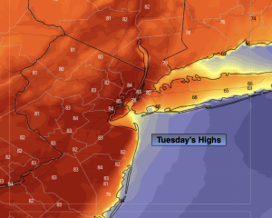
It’ll feel more like June today due to a Southwest wind around a Western Atlantic high. Temperatures will top 80º in many areas. Skies will be mostly sunny.
Please use caution with flammables outdoors. The ground is dry and any spark may result in the start of a wild fire. Winds will be gusty aiding to the possible spread.
Wednesday will still be mild. Showers are likely anytime after mid-morning as a front moves in from the West. Seasonal temperatures are expected. The average high is around 70º.
More clouds than sun is expected Thursday as the front remains just offshore. It now looks to be dry.
A mix of sun and clouds is expected for Friday along with a gusty Northwest wind. Temperatures will be several degrees below average.
A front will move in on Saturday. Skies will be mostly cloudy. Showers are possible for a few hours. It doesn’t look like a washout.
The weather should cooperate on Mother’s Day. At this time it looks to be partly sunny and warm.
Stay tuned.
Keep it here for a no nonsense, no hype forecast…
Tuesday:
Mostly sunny and breezy. Warmer. Highs in the lower 80s. Southwest winds at 15-25mph with gusts to 30mph.
Tonight:
Mostly cloudy. Mild. Lows around 60º in the City, the 50s inland. Southwest winds at 10-15mph.
Wednesday:
Mostly cloudy. Scattered showers from mid-morning on. Highs in the upper 60s.
Thursday:
Mostly cloudy. Highs in the mid 60s.
Friday:
Partly sunny. Highs in the mid 60s.
Saturday:
Mostly cloudy. Chance of showers. Highs in the mid 60s.