Synopsis:
It’ll get progressively warmer today and Tuesday with a Southwest wind around a Western Atlantic high. Temperatures will top 80º in many areas Tuesday.
Please use caution with flammables outdoors. The ground is dry and any spark may result in the start of a wild fire. Winds will be gusty aiding to the possible spread.
Wednesday will still be mild. Showers will develop later in the day and continue into the first part of Thursday as a cool front moves toward the region. Temperatures will be cooler on Thursday.
A mix of sun and clouds is expected for Friday along with a gusty Northwest wind. Temperatures will be several degrees below the average high of around 70º.
Stay tuned.
Keep it here for a no nonsense, no hype forecast…
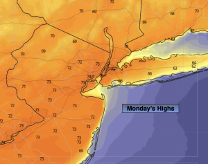
Monday:
Mostly sunny, breezy and milder. Highs in the lower 70s. Southwest winds at 10-20mph with gusts to 25mph.
Tonight:
Mostly clear. Lows around 60º in the City, near 50º inland. Southwest winds at 8-12mph.
Tuesday:
Mostly sunny and breezy. Warmer. Highs in the lower 80s.
Wednesday:
Mostly cloudy. Shower chance later in the day. Highs in the lower 70s.
Thursday:
Mostly cloudy. Shower chance. Highs in the lower to mid 60s.
Friday:
Partly sunny. Highs in the lower to mid 60s.