Synopsis:
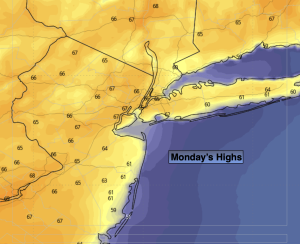
High pressure over the Northeast will result in a gorgeous Monday across the area. Wall to wall sunshine is expected with mild readings. High will be a few degrees above the average high of the mid 60s.
A mix of sun and clouds is expected for Tuesday as the high moves off the coast. Seasonal temperatures are anticipated.
A cool front will approach Wednesday. Any sun will give way to clouds. Showers are likely later in the day and at night.
Morning showers Thursday should give way to some afternoon sun. Temperatures will be below average.
May’s debut on Friday will be pleasant under a mix of sun and clouds.
Stay tuned.
Keep it here for a no nonsense, no hype forecast…
Monday:
Sunny. Highs in the mid to upper 60s. Northeast to Southeast winds at 5-10mph.
Tonight:
Mostly clear. Lows around 50º in the City, the upper 30s to lower 40s inland. Southeast winds less than 5mph.
Tuesday:
Mostly sunny. Highs in the mid 60s.
Wednesday:
Mostly cloudy. Showers likely later in the day. Highs in the lower 60s.
Thursday:
Morning showers to afternoon sun. Highs in the upper 50s.
Friday:
Partly sunny. Highs around 60º.