Synopsis:
Monday will feature a pop in temperatures with highs getting into the upper 70s as a strong Southwest flow begins to take hold. Tuesday through Thursday will be a Summer preview with highs reaching well into the 80s. The weather pattern will be more reminiscent of July than April as a Bermuda high dominates.
A weak front will move through Friday uneventful. Readings will cool down but still be well above the average high of the lower 60s for this time of the year.
Our dry streak continues. Please use caution with flammables outdoors as the spread for wild fires is a concern.
Stay tuned.
Keep it here for a no nonsense, no hype forecast…
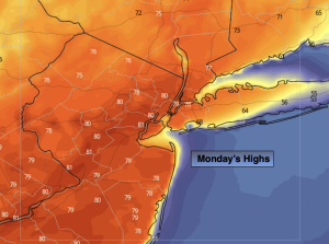
Monday:
Partly sunny, breezy and much warmer. Highs in the upper 70s. Cooler at the coast. Southwest winds at 15-25mph with gusts to 30mph.
Tonight:
Mostly clear. Mild. Lows in the lower 60s in the City, the 50s inland. West to Southwest winds at 5-10mph.
Tuesday:
Partly sunny. Warm. Highs in the lower 80s.
Wednesday:
Partly sunny. Very warm. Highs in the upper 80s.
Thursday:
Partly sunny. Very warm. Highs in the upper 80s.
Friday:
Partly sunny. Still warm. Highs around 80º.