Synopsis:
Welcome to April and it’s no joke on this April Fool’s Day that it’ll feel more like June. It’ll be warm ahead of a cold front moving through. A spotty shower is possible just about any time. The best chance for showers will be later this afternoon into early tonight with the front.
There will be a dramatic temperature swing on Thursday as high pressure over Southeastern Canada funnels in cooler air. Temperatures will be nearly thirty degrees cooler than today! Patchy drizzle is possible with the flow off the ocean along with a stationary front to our South.
A warm front will move through the region Friday morning. Clouds will give way to partly sunny skies. It’ll be milder.
Saturday will be warmer as a Southwest flow dominates. A few showers can’t be ruled out.
Easter Sunday looks warm with a chance of showers by mid-afternoon . The egg rolls and bonnets should be dry for the morning hours!
Stay tuned.
Keep it here for a no nonsense, no hype forecast…
Wednesday:
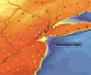
Mostly cloudy. Chance of afternoon showers. Warm. Highs in the mid 70s. West to North winds at 8-12mph.
Tonight:
Scattered showers. Lows in the 40s throughout. Northeast winds at 10-20mph.
Thursday:
Cloudy. Patchy drizzle. Much cooler. Highs in the upper 40s.
Friday:
Clouds to sun. Mild. Highs in the mid 60s.
Saturday:
Mostly cloudy. A few showers possible. Warmer. Highs in the lower to mid 70s.
Easter Sunday:
Some morning sun to afternoon showers. Warm. Highs in the lower 70s.