Synopsis:
A warm front will approach today. A mix of sun and clouds is expected. It’ll be mild. Tuesday will be even warmer as the front moves to our North. A few showers are possible in the early morning, otherwise skies will be partly sunny. Wednesday- April’s debut will feature warm readings with a chance of showers in the afternoon as a cold front move in.
There will be a dramatic temperature swing on Thursday as high pressure over Southeastern Canada funnels in cooler air. At the same time patchy drizzle can be expected as the front to our South continues to be throw moisture in our direction.
Weak low pressure will be over the Northeast on Friday. More clouds than sun is expected with a chance of a few showers. It’ll be milder.
Stay tuned.
Keep it here for a no nonsense, no hype forecast…
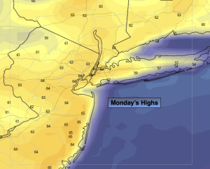
Monday:
Partly sunny. Mild. Highs in the lower to mid 60s. Southwest winds at 10-20mph.
Tonight:
Mostly cloudy. Scattered showers. Mild. Lows in the 50s throughout. Southwest winds at 5-10mph.
Tuesday:
Spotty morning showers, otherwise partly sunny. Warmer. Highs in the mid 70s.
Wednesday:
Sun to clouds. Chance of afternoon showers. Warm. Highs in the mid 70s.
Thursday:
Cloudy. Patchy drizzle. Much cooler. Highs around 50º.
Friday:
Mostly cloudy. A few showers possible. Mild. Highs around 60º.