Synopsis:
Despite abundant sunshine today readings will be five to ten degrees below the average high of the lower to mid 50s. At least the sun will be shining. Sunday will be bright and seasonal with high pressure overhead.
A warm front will approach on Monday. This will result in mostly cloudy skies. It’ll be mild. Tuesday will be even warmer as the front moves to our North. A few showers are possible under a mix of sun and clouds. Wednesday- April’s debut will feature warm readings with a chance of showers as a cold front move in.
Stay tuned.
Keep it here for a no nonsense, no hype forecast…
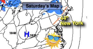
Saturday:
Mostly sunny. Chilly. Highs in the mid 40s. Northwest winds at 15-25mph.
Tonight:
Mostly clear. Cold. Lows near freezing for urban areas, the upper teens and 20s inland. Light North wind becoming South.
Sunday:
Sunny. Seasonal. Highs in the lower 50s.
Monday:
Mostly cloudy. Mild. Highs around 60º.
Tuesday:
Mostly cloudy. Spotty showers. Warmer. Highs in the lower 70s.
Wednesday:
Sun to clouds. Chance of showers. Warm. Highs in the mid 70s.