Synopsis:
Spring arrives at 10:46am today. And not a day too soon! High pressure will be off the Eastern Seaboard. Readings will be milder with the Southerly flow, The exception will be along the coast with the chilly Atlantic breeze. Sun will give way to clouds as a cool front works in by evening. Showers are expected toward sunset.
The first weekend of Spring will be a winner. Bright skies and well above average temperatures are expected. Readings by Sunday will reach well into the 60s!
A cool front will move through on Sunday evening and night with showers. Monday will be more seasonal with readings in the lower 50s.
Cold high pressure will move overhead on Tuesday. Sunny skies and cool temperatures are anticipated.
Stay tuned.
Keep it here for a no nonsense, no hype forecast…
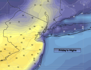
Friday:
Sun to clouds. Mild. Showers by evening. Highs in the mid 50s. South winds at 8-15mph.
Tonight:
Showers. Lows in mid 40s in the City, around 40º inland. Southwest to West winds at 8-12mph.
Saturday:
Mostly sunny. Mild. Highs around 60º.
Sunday:
Partly sunny. Milder. Showers by evening. Highs in the mid 60s.
Monday:
Partly sunny, more seasonal. Highs in the lower 50s.
Tuesday:
Sunny and cool. Highs in the mid 40s.