Synopsis:
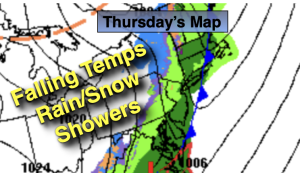
A cold front will move through the region this morning. It’ll be mild in the early morning with readings around 60º. Showers will accompany the front and temperatures will drop during the day. Readings will fall into the 40s during the afternoon. A few snow showers are possible during the mid to late afternoon!
More seasonal conditions are expected for Friday as cooler air settles upon the region. Saturday will be bright and pleasant as high pressure moves overhead. Sunday will feature more clouds as a warm front struggles to move through.
A cold front will pass the region midday Monday with showers. It’ll be mild.
Stay tuned.
Keep it here for a no nonsense, no hype forecast…
Thursday:
Scattered morning showers. A few snow showers possible later in the day. Early morning highs around 60º. Temperatures falling through the 40s during the afternoon. Northwest winds at 15-25mph.
Tonight:
Mostly clear. Much colder. Lows around freezing in the City, the 20s inland. West to Northwest winds at 10-20mph.
Friday:
Partly sunny. Seasonal. Highs in the mid to upper 40s.
Saturday:
Mostly sunny and pleasant. Highs in the lower 50s.
Sunday:
Clouds, some sun. Highs in the upper 40s.
Monday:
Showers. Mild. Highs around 60º.