Synopsis:
It’ll feel like May through Wednesday with readings more than twenty degrees above the average high of the upper 40s. This is all due to a Strong Western Atlantic high pumping up warm air from the South and West. Mainly sunny skies are expected. Temperatures will be cooler along the shore and over parts of Long Island due to the much colder Atlantic sea breeze.
A cold front will move through the region Thursday morning. It’ll be mild to start. Showers will accompany the front and temperatures will drop during the afternoon.
More seasonal conditions are expected for Friday as cooler air settles upon the region.
Stay tuned.
Keep it here for a no nonsense, no hype forecast…
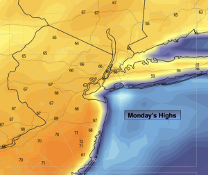
Monday:
Sunny. Mild. Highs in the mid to upper 60s. Warmer inland, cooler at the coast. Southwest to South winds at 5-10mph.
Tonight:
Mostly clear. Lows around 50º along the coast, the 30s & 40s inland. South winds at 5mph.
Tuesday:
Mostly sunny. Highs in the upper 60s. Warmer inland, cooler at the coast.
Wednesday:
Partly sunny. Highs around 70º. Warmer inland, cooler at the coast.
Thursday:
A period of morning rain, otherwise becoming mostly sunny. Early highs around 60º. Temperatures falling during the afternoon.
Friday:
Partly sunny. Seasonal. Highs in the upper 40s.