Synopsis:
A moist flow off the ocean will continue today. This will result in spotty drizzle and areas of fog this morning. Clouds will hang tough for this afternoon. A cool front will approach tonight and Sunday morning accompanied by scattered showers. Sunday afternoon will feature a mix of sun and clouds along with milder readings. Mild conditions will continue into Monday with high pressure off the Southeast coast. Temperatures will continue to rise through midweek. Highs may get into the 70s away from the colder Atlantic by Wednesday.
We “Spring Ahead” this Sunday. Set the clocks ahead one hour Sunday at 2am as Daylight Saving Time begins. The sun will set an hour later. Yes! It’s also a good time to check the batteries in your smoke and carbon monoxide detectors.
Stay tuned.
Keep it here for a no nonsense, no hype forecast…
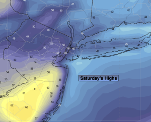
Saturday:
Spotty morning drizzle and fog. Remaining mostly cloudy. Highs around 50º. Southeast winds at 5mph.
Tonight:
Scattered showers. Lows in the 40s throughout. Southeast to Southwest winds at 5mph.
Sunday:
Morning spotty shower, otherwise, becoming partly sunny. Milder. Highs in the mid 60s. Cooler at the coast.
Monday:
Partly sunny. Highs in the lower to mid 60s. Warmer inland, cooler at the coast.
Tuesday:
Partly sunny. Highs in the mid 60s. Warmer inland, cooler at the coast.
Wednesday:
Partly sunny. Highs around 70º. Warmer inland, cooler at the coast.