Synopsis:
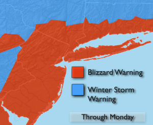
BLIZZARD WARNING now in affect for the entire tri-state area. THIS will be a dangerous storm.
Light snow and some rain is expected for the first part of today. It will go over to all snow during the afternoon. The brunt of the storm will be tonight through Monday morning. Prepare now. The snow will taper off Monday afternoon.
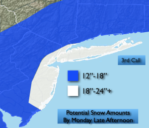
Bombogenesis will occur. This is a meteorological term. The “birth” of a bomb- a rapidly deepening storm of a drop in atmospheric pressure of 24mb with 24 hours (in this case it may happen within 12-18 hours!). A classic Nor’easter. The storm will bring very heavy snowfall at 2″/hr, 40-60mph winds, thunder snow and whiteout conditions. The potential is there for one to possibly close to two feet of snow in spots. I’ll adjust these amounts, if need be, with a look at the latest computer guidance later today.
Moderate to major coastal flooding of 1′-3′ of inundation is possible at times of high tide. If your area is prone to tidal flooding please take precautions.
Tuesday will feature high pressure moving in. Sunny skies and just below seasonal average temperatures can be expected.
Scattered snow showers are possible Wednesday. Thursday will feature a warm front approaching. A mix to rain is possible later in the day and a night.
Keep it here for a no nonsense, no hype forecast…
Sunday:
Rain and snow changing to a steadier snow later in the day. Highs in the mid to upper 30s. Northeast winds at 10-15mph with gusts to 20mph later in the day. Northeast 10-15mph gusts to 20mph.
Tonight:
Blizzard conditions. Snow, heavy at times. Whiteout conditions. Thunder snow. Lows in the upper 20s throughout. Northeast to North winds at 15-30mph gusts 40-55mph.
Monday:
Snow. Possibly heavy at times in the morning. Very windy. Snow will taper off during the afternoon. Highs around freezing.
Tuesday:
Mostly sunny. Highs in the upper 30s.
Wednesday:
Mostly cloudy with scattered snow showers. Highs near 40º.
Thursday:
Mostly cloudy. Late day mix possible. Highs in the lower 40s.