Synopsis:
Clouds will continue to dominate on Saturday as weather systems remain weak over the region. It’ll be milder.
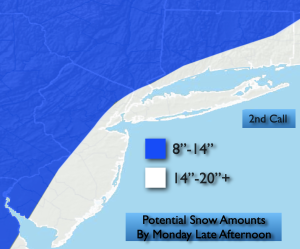
BLIZZARD WARNING. For all of NYC, Long Island, Coastal NJ/CT. THIS will be a dangerous storm. Bombogenesis will occur. A classic Nor’easter will bring very heavy snowfall at 2″/hr, 40-60mph winds and thunder snow. Potential snow amounts continue to go up. It starts as on and off light snow and some rain Sunday morning then goes over to all snow toward sunset. The brunt of the storm will be Sunday night through Monday morning. A foot of snow will be common with coastal areas approaching 20″. These amounts will get altered as new computer guidance come in. Prepare now. The snow will taper off Monday afternoon.
Tuesday will feature high pressure moving in. Sunny skies and just below seasonal average temperatures can be expected.
Keep it here for a no nonsense, no hype forecast…
Saturday:
Mostly cloudy. Milder. Highs in the mid to upper 40s. West winds at 5-10mph.
Tonight:
Mostly cloudy. Lows in the lower to mid 30s throughout. West winds at 5-10mph.
Sunday:
Rain and snow changing to a steadier snow by evening. Heavy snow and high winds for most areas Sunday night. Highs in the mid to upper 30s.
Monday:
Snow. Possibly heavy at times in the morning along and East of I-95. Very windy. Snow will taper off during the afternoon. Highs around freezing.
Tuesday:
Mostly sunny. Highs in the upper 30s.