Synopsis:
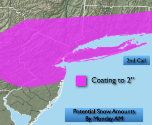
A bit of snow continues in the forecast for tonight. The potential is there for a coating to two inches of snow for much of the region. Snow and rain is likely for Southern NJ. This is a quick hitter, starting late evening and should clear the region well before sunrise Monday.
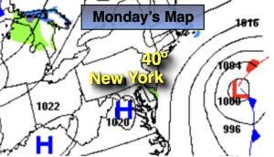
Presidents’ Day will feature increasing sunshine and near average temperatures as high pressure moves in from the West.
Tuesday will start off with clouds but the sun will return by afternoon. It’ll be milder as high pressure over the Southeast pumps up a Southwesterly flow.
On Wednesday a stationary front will result in clouds and the possibility of rain showers.
A partly sunny sky is expected on Thursday along with mild readings.
Friday will be unsettled as weak low pressure scoots to our South. Some rain is likely. A potential mix exists for Northern areas.
Keep it here for a no nonsense, no hype forecast…
Tonight:
A period of light snow. Snow and rain over Southern areas. Lows around freezing along the coast, the upper 20s inland. East to Northeast winds at 8-12mph.
Presidents’ Day:
Clouds to sun. Highs around 40º.
Tuesday:
Clouds to sun. Milder. Highs in the mid 40s.
Wednesday:
Mostly cloudy. Scattered showers. Highs in the lower 40s.
Thursday:
Partly sunny. Highs in the lower to mid 40s.
Friday:
Areas of rain. A mix possible well North. Highs in the lower 40s.