Synopsis:
Sunny skies and chilly temperatures are expected today as high pressure influences the region. A weak disturbance moving through the area tonight will result in scattered snow showers. A dusting or coating is possible in spots.
The weekend looks dry with high pressure moving off the East coast. Abundant sunshine is expected Saturday with tolerable temperatures. Sunday will feature developing low pressure to the Southwest. Any sun will give way to clouds. Most of the computer guidance keeps this system as a Southern slider- missing our area Sunday night. The exception maybe Central and Southern NJ. A bit of light rain may fall for at time at night.
Presidents’ Day will feature sunshine and near average temperatures as high pressure moves in from the West.
Tuesday will be bright and milder as high pressure over the Southeast influences our region.
Keep it here for a no nonsense, no hype forecast…
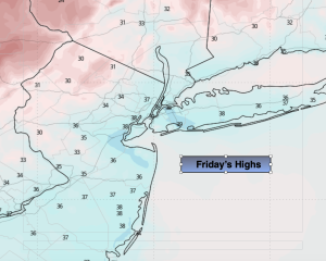
Friday:
Sunny. Highs in the mid 30s. Northwest winds at 8-12mph.
Tonight:
Becoming mostly cloudy. Scattered snow showers are likely. Lows around 30º along the coast, the teens and 20s inland. West winds at 5mph.
Saturday:
Mostly sunny. Seasonable. Highs in the lower 40s.
Sunday:
Sun to clouds. Highs in the upper 30s.
Presidents’ Day:
Partly sunny. Highs around 40º.
Tuesday:
Mostly sunny. Milder. Highs in the lower to mid 40s.