Synopsis:
Sunny skies and seasonably cold temperatures are expected today and Friday as high pressure influences the region. The sun will dominate.
The weekend looks dry. Abundant sunshine is expected Saturday with tolerable temperatures. Sunday will feature developing low pressure to the Southwest. Most of the computer guidance keeps this system as a Southern slider- missing our area. Any sun will give way to clouds Sunday. Stay tuned as the exact track is not etched in stone, but this scenario has been the trend.
Presidents’ Day will feature sunshine and near average temperatures as high pressure moves in from the West.
Keep it here for a no nonsense, no hype forecast…
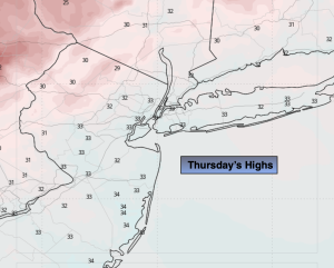
Thursday:
Mostly sunny. Breezy. Highs in the mid 30s. Northwest winds at 10-20mph with gusts to 25mph.
Tonight:
Mostly clear. Lows in the mid 20s along the coast, the teens and 20s inland. Northwest winds at 10-15mph diminishing late.
Friday:
Sunny. Highs in the mid 30s.
Saturday:
Mostly sunny. Seasonable. Highs around 40º.
Sunday:
Sun to clouds. Highs around 40º.
Presidents’ Day:
Partly sunny. Highs in the lower 40s.