
Synopsis:
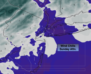
It’ll be a frigid Sunday despite the sunshine. Arctic high pressure will continue to dominate the Northeast. Temperatures today will remain in the teens with wind chills during the afternoon hovering around 0º. Please use caution outdoors and keep all exposed skin covered to prevent frostbite. Thankfully, the winds will not be as strong as yesterday, but it will still be a slap in the face walking outdoors.
Tonight will be bitter with lows inland falling once again below zero.
The center of the high will be over the region on Monday. Temperatures will moderate but still remain several degrees below freezing. We’ll finally break the freezing mark as a southwest wind develops around the departing high pressure on Tuesday. Mostly cloudy skies are expected as a weak frontal boundary moves to our North.
The low potential of a light wintry mix for midweek is off the table. It should remain dry Tuesday night. A cold front will push through by Wednesday morning. Sunny skies and seasonably cold temperatures are expected through Thursday under mainly sunny skies.
Stay tuned.
Keep it here for a no nonsense, no hype forecast…
Sunday:
Mostly sunny, windy and bitterly cold. Highs in the mid to upper teens. Wind chills near 0º during the afternoon. Northwest winds at 15-25mph with gusts to 30mph.
Tonight:
Clear and Frigid. Diminishing winds. Lows around 12º along the coast, around -5º to 5º inland. Northwest winds 5-10mph after midnight.
Monday:
Sunny. Not as brutal. Highs in the upper 20s.
Tuesday:
Mostly cloudy. Highs in the mid 30s.
Wednesday:
Partly sunny. Highs in the mid 30s.
Thursday:
Mostly sunny. Highs around freezing.