Synopsis:
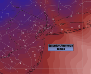
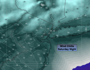
An Arctic blast has arrived. Early morning highs of the lower 20s will fall into the lower teens during the afternoon Saturday. A biting wind will result in dangerous wind chills. Winds will gust to 50mph today as the pressure gradient over the region is very tight. Wind chills will drop to -10 to -15º along the coast to -20 to -25º well inland tonight. Please use caution outdoors and keep all exposed skin covered to prevent frostbite. Highs on Sunday will remain in the teens. Thankfully, the winds will have diminished some. Mostly sunny skies are expected both weekend days.
Temperatures will slowly recover to near freezing by Tuesday as the Arctic airmass moves out. Dry conditions are expected.
A weak area of low pressure may move over the region on Wednesday. If this occurs a light mix may occur. This is a low potential at this time. A few models have it dry on Wednesday.
Stay tuned.
Keep it here for a no nonsense, no hype forecast…
Saturday:
Mostly sunny, windy and bitterly cold. Temperatures dropping through the teens and into the single digits North and West. Wind gusts up to 50mph. Wind chills near 0º along the coast. 0º to -7º inland.
Tonight:
Frigid. Windy. Lows around 5º along the coast, around 0º inland. Wind chills -10 to -25º. Northwest winds at 15-30mph with gusts to 40mph.
Sunday:
Mostly sunny, windy and bitterly cold. Highs in the mid to upper teens. Wind chills near 0º.
Monday:
Partly sunny. Still cold. Highs in the mid to upper 20s.
Tuesday:
Partly sunny. Highs near freezing.
Wednesday:
Low potential for a light mix. Highs in the mid 30s.