Synopsis:
More clouds are expected today as a cold front moves into the Eastern Ohio Valley. Temperatures will once again approach freezing.
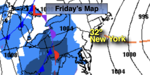
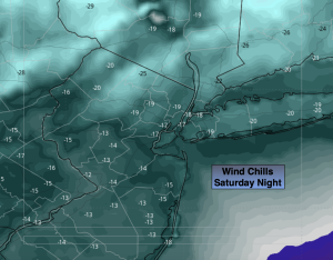
Scattered snow showers are possible this evening and tonight as the Arctic front approaches. It doesn’t look to be a big deal. An inch of snow may fall in spots by Saturday AM. The big deal will be the Arctic blast that will arrive this upcoming weekend. Temperatures will only be in the teens during the day with a biting wind and dangerous wind chill. Winds will gust to 50mph on Saturday as the pressure gradient over the region is very tight. Wind chills will drop to -10 to -15º along the coast to -20 to -25º well inland Saturday night. Please use caution outdoors and keep all exposed skin covered to prevent frostbite. Mostly sunny skies are expected both weekend days.
Temperatures will slowly recover to near freezing by Tuesday as the Arctic airmass moves out. Dry conditions are expected.
Stay tuned.
Keep it here for a no nonsense, no hype forecast…
Friday:
Mostly cloudy. Scattered snow showers possible during the evening. Highs around freezing. Light and variable winds.
Tonight:
Scattered snow showers. Lows around 20º along the coast, the teens inland. Southwest to West winds 5-10mph.
Saturday:
Mostly sunny, windy and bitterly cold. Temperatures dropping through the teens during the day. Wind gusts up to 50mph. Wind chills near 0º during the day, -10 to -25º wind chills at night.
Sunday:
Mostly sunny, windy and bitterly cold. Highs in the upper teens. Wind chills near 0º.
Monday:
Partly sunny. Still cold. Highs in the mid to upper 20s.
Tuesday:
Partly sunny. Highs near freezing.