Synopsis:
Today and Thursday will feature readings within a few degrees of freezing along with mostly sunny skies as high pressure dominates.
On Friday, a cold front will be approaching. Sun will give way to clouds. Scattered snow showers are possible in the evening and at night. It doesn’t look to be a big deal. The big deal will be the Arctic blast that will arrive this upcoming weekend. Temperatures will only be in the teens with a biting wind and dangerous wind chill. Sigh…
Stay tuned.
Keep it here for a no nonsense, no hype forecast…..
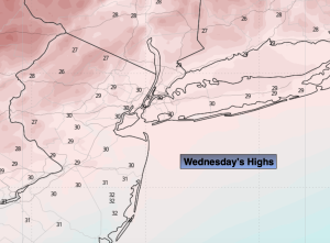
Wednesday:
Partly sunny. Highs around freezing. Northwest winds at 8-12mph.
Tonight:
Mostly clear. Lows in the mid 20s along the coast, the single digits and teens inland. North/Northwest wind to 5-10mph
Thursday:
Mostly sunny. Highs around 30º.
Friday:
Sun to clouds. Scattered snow showers possible during the evening. Highs around 30º.
Saturday:
Mostly sunny, windy and bitterly cold. Highs around 20º. Wind chills near 0º.
Sunday:
Mostly sunny, windy and bitterly cold. Highs in the upper teens. Wind chills near 0º.