Synopsis:
The coldest air of this bitter blast will be with us today and tonight. Readings will only be in the teens for highs today. Wind chills will fall be in the single digits to below zero this morning. PLEASE dress for the severe cold. Frost bite can occur very quickly. The sun will at least be shining. Temperatures tonight will fall well below zero in spots inland.
Saturday will be frigid with a mix of sun and clouds.
JMW will continue with a low potential of some light coastal snow Sunday. The computer models have a rapidly intensifying storm well off the Mid-Atlantic coast. The models have agreed on a more offshore track. The Northwestern shield of snow may just graze coastal communities on Sunday. Most areas will remain snow-free. Accumulations will be light, if any. It will be windy and very cold Sunday. We’ll continue to monitor the latest computer guidance.
Monday and Tuesday will finally offer some relief from the Arctic airmass. The core of the cold dome will move East allowing temperatures to rise to near freezing. A mix of sun and clouds are expected.
Stay tuned.
Keep it here for a no nonsense, no hype forecast….
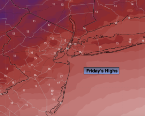
Friday:
Mostly sunny. Bitter cold. Highs in the mid to upper teens. Wind chills in the single digits during the afternoon. West to Northwest winds at 10-20mph with gusts to 30mph.
Tonight:
Partly cloudy. Lows in the upper single along the coast, the single digits to -10º inland. Diminishing Northwest wind 5-10mph.
Saturday:
Partly sunny. Cold. Highs around 20º.
Sunday:
Mostly cloudy and windy. Low potential of some coastal snow. Highs in the mid 20s.
Monday:
Mostly sunny. Highs in the lower 30s.
Tuesday:
Partly sunny. Highs around freezing.