Synopsis:
It’s the same ol’ story with the bitter cold. Canadian air will continue to pour into our region. Temperatures will remain well below average and wind chills will be an issue. The snow on the ground will be with us for some time. Please use caution while traveling. A mix of sun and clouds is expected through Saturday. Stay warm.
There is a low potential of some coastal snow Sunday. The computer models do have low pressure developing off the Southeast coast. How far North it goes up and off the coast will determine how much, if any snow the tri-state area will see. The coast will have the greatest threat of seeing any snow. It will be windy. We’ll continue to monitor the latest computer guidance.
Stay tuned.
Keep it here for a no nonsense, no hype forecast….
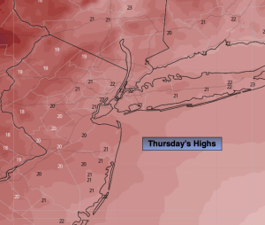
Thursday:
Mostly sunny. Bitter cold. Highs in the lower 20s. Wind Chills in the single digits and teens. Northwest winds at 10-20mph with gusts to 25mph.
Tonight:
Partly cloudy. Lows in the lower teens along the coast, the single digits to -10º inland. West winds at 8-12mph. Wind chills 0º to -15º.
Friday:
Mostly sunny. Bitter cold. Highs in the upper teens.
Saturday:
Partly sunny. Cold. Highs in the mid 20s.
Sunday:
Mostly cloudy and windy. Low potential of some coastal snow. Highs in the mid 20s.
Monday:
Partly sunny. Highs in the lower 30s.