Synopsis:
Today will be colder under a bright sky. Another bitter blast will arrive tonight and Saturday as the Canadian Arctic gates are wide open. Saturday’s highs may only remain in the teens.
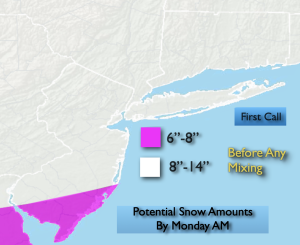
The confidence in a significant snowfall continues to increase. Snow will fall on Sunday as low pressure to the South collides with a bitter cold high to the North. The snow looks to start in the early morning and continue throughout the day. The snow will come down heavy at times at the rate of possibly 1″-2″/hour for a few hours Sunday. Significant accumulations are likely. The “first call” map is above. The potential amounts of 8″-14″ is now on the table by Monday morning.
All of the models have come North with low pressure. A warm wedge of air aloft will ride up through Southern and central NJ later Sunday. I’m a bit more confident that a mix will occur from the I-78 corridor, through the City and into Long Island. But before this happens heavy amounts of snow will have fallen. Potential snow amounts to the South will most likely be adjusted as you can see the lower band over Southern sections.
The snow/mix will be falling with bitterly cold readings. It’ll be quite dangerous to be outdoors with this combination.
Any morning light snow will end Monday. It’ll breezy and very cold.
Another Arctic blast will arrive on Tuesday. We are having a January that we haven’t seen in years.
Stay tuned.
Keep it here for a no nonsense, no hype forecast…
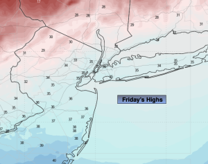
Friday:
Mostly sunny. Colder. Highs in the lower to mid 30s. West to Northwest winds at 15-25mph with higher gusts.
Tonight:
Mostly clear. Bitterly cold. Lows around 10º along the coast, 0º to 7º inland. Wind chills will be below zero. Northwest 15-25mph gusts to 35mph.
Saturday:
Partly sunny. Frigid. Highs in the upper teens.
Sunday:
Snow/mix likely. Heavy at times. Frigid. Highs 17º-25º.
Monday:
AM light snow ends. Some afternoon sun. Cold. Highs in the mid 20s.
Tuesday:
Mostly sunny. Bitter cold. Highs only around 20º.