Synopsis:
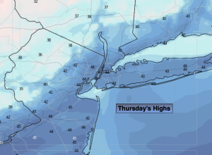
It won’t be as harsh today. It’ll actually feel like a heat wave with highs getting into the 40s! High pressure to our South and West will be responsible for pleasant break
Friday will be colder under a bright sky. Another bitter blast will arrive Friday Night and Saturday as the Canadian Arctic gates are wide open. Saturday’s highs may only remain in the teens.
Snow looks like a good bet Sunday as low pressure to the South collides with a bitter cold high to the North. The snow looks to start in the early morning and continue throughout the day. At this time the potential for significant accumulations has increased. All of the models have come North with low pressure. Putting a number on this, at this present moment, would be a potential 6″-12″. This is a generalization output and will be fine tuned as more guidance comes in over the next couple of days. Some mixing is possible over central and Southern areas. The snow will be falling with bitterly cold readings. It’ll be quite dangerous to be outdoors with this combination.
Any morning light snow will end Monday. It’ll breezy and very cold.
Stay tuned.
Keep it here for a no nonsense, no hype forecast…
Thursday:
Mostly sunny. Much better feel. Highs in the lower to mid 40s. West winds at 10-20mph.
Tonight:
Partly cloudy. Lows around 30º along the coast, the 20s inland. West winds at 8-12mph.
Friday:
Mostly sunny. Colder. Highs around freezing.
Saturday:
Partly sunny. Frigid. Highs in the upper teens.
Sunday:
Snow likely. Frigid. Highs around 20º.
Monday:
AM light snow ends. Some afternoon sun. Cold. Highs in the mid 20s.