Synopsis:
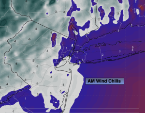
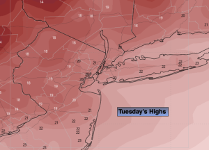
An Arctic blast will arrive tonight and Tuesday. Highs Tuesday will only be in the lower 20s with a frigid wind to add to the misery. Wind chills will be in the 5º to -7º range Tuesday morning.
Wednesday readings will struggle to get just above freezing as the core of the cold airmass moves out. It won’t be as harsh on Thursday as the cold high slips offshore. It’ll actually feel like a heat wave with highs topping 40º!
Friday will be colder under a bright sky. Another bitter blast will arrive Friday Night and Saturday as the Canadian Arctic gates are wide open.
The potential exists for some snow Saturday night and Sunday as low pressure to the South collides with a bitter cold high to the North. This is way down the pike and no specifics are likely for a few days. We’ll continue to monitor this potential.
Stay tuned.
Keep it here for a no nonsense, no hype forecast…
Tonight:
Mostly clear and frigid. Breezy. Lows in the teens throughout. Wind chills near 0º. West 15-25mph gusting to 30mph.
Tuesday:
Mostly sunny. Breezy. Very cold. Highs in the lower 20s. West winds at 15-25mph.
Wednesday:
Partly sunny. Breezy. Not as cold. Highs in the lower 30s.
Thursday:
Mostly sunny. Not as harsh. Highs around 40º.
Friday:
Mostly sunny. Colder. Highs around freezing.
Saturday:
Thickening clouds. Frigid. Highs in the upper teens.