Synopsis:
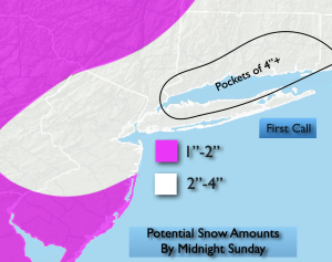
Snow (rain turning to snow to the South) will end later this evening. Much of the region looks to receive 2″-4″ of snow with lighter amounts over Southern NJ. The jackpot zone looks to be North and East of the City.
MLK Day will feature mostly sunny skies and colder readings. Highs will be near freezing. An Arctic blast will arrive late day Monday and into Tuesday. Highs Tuesday will only be in the lower 20s with a frigid wind to add to the misery.
Wednesday readings will struggle to get to freezing as the core of the cold airmass moves out. It won’t be as harsh on Thursday as the cold high slips offshore.
Another bitter blast will arrive Friday as the Canadian Arctic gates are wide open.
Stay tuned.
Keep it here for a no nonsense, no hype forecast…
Tonight:
Snow (rain south turning to snow) early, tapering off from West to East during the late evening. Lows in the mid to upper 20s throughout. North to Northwest winds at 5-10mph.
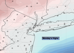
MLK Day:
Mostly sunny, breezy and cold. Highs in the lower to mid 30s. West 15-25mph gusting to 30mph.
Tuesday:
Mostly sunny. Breezy. Frigid. Highs in the lower 20s.
Wednesday:
Partly sunny. Breezy. Cold. Highs in the lower 30s.
Thursday:
Mostly sunny. Not as harsh. Highs in the mid to upper 30s.
Friday:
Mostly sunny. Much colder. Highs in the upper 20s.