Synopsis:
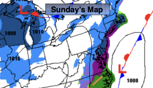
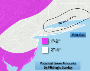
A second round of snow for many will occur today as low pressure takes shape off the Mid-Atlantic coast. The forecast looks on track. On and off snow today of varying intensities. Coastal and Southern areas may experience more rain and or a mix for much of the day. There looks to be a lull in the action for parts of the area later this am or afternoon. So don’t be surprised if it stops. As the storm gets going later today and this evening any rain South will go over to a burst of accumulating snow. The challenge here is how far west will the significant band of accumulating be? This all ends from West to East later this evening and after midnight East of the City. Much of the region looks to receive 2″-4″ of snow with lighter amounts over Southern NJ. The jackpot zone looks to be North and East of the City.
MLK Day will feature mostly sunny skies and colder readings. Highs will be near freezing. An Arctic blast will arrive late day Monday and into Tuesday. Highs Tuesday will only be in the lower 20s with a frigid wind to add to the misery.
Wednesday readings will struggle to get to freezing as the core of the cold airmass moves out. It won’t be as harsh on Thursday as the cold high slips offshore.
Stay tuned.
Keep it here for a no nonsense, no hype forecast…
Sunday:
Periods of snow. A mix or rain over Southern sections. Highs in the lower to mid 30s. North to Northeast winds at 5-10mph.
Tonight:
Snow early, tapering off from West to East during the late evening. Lows in the mid to upper 20s throughout. North to Northwest winds at 5-10mph.
MLK Day:
Mostly sunny, breezy and cold. Highs in the lower to mid 30s.
Tuesday:
Mostly sunny. Breezy. Frigid. Highs in the lower 20s.
Wednesday:
Partly sunny. Breezy. Cold. Highs in the lower 30s.
Thursday:
Mostly sunny. Not as harsh. Highs in the mid to upper 30s.