Synopsis:
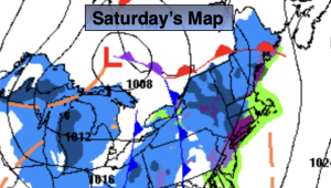
This weekend will be a bit unsettled. There will be upper level energy working over the region. It’ll come in two shots. Areas of on and off light snow and rain (depending on your temperature) will be likely on Saturday. A light accumulation is possible over the Northern half of the region. The possibility of a few inches is there for Northwestern areas mainly on colder surfaces. Southern areas will see little in the way of precipitation and it may end up being dry.
The second threat will be on Sunday. There will be a developing area of offshore low pressure. At this time it looks like most of the snow will stay East of the region. Mainly cloudy skies are expected for Sunday. If the band of snow moves farther West a brush of light snow is possible at the coast. This is a low potential at this time.
MLK Day will feature mostly sunny skies and colder readings. Highs will be near freezing. An Arctic blast will arrive late day Monday and into Tuesday. Highs Tuesday will only be in the lower 20s with a frigid wind to add to the misery.
Wednesday readings will struggle to get to freezing as the core of the cold airmass moves out.
Stay tuned.
Keep it here for a no nonsense, no hype forecast…
Saturday:
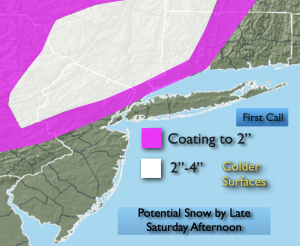
Mostly cloudy with areas of on and off snow and rain. Remaining dry to the South. Highs in the 30s to around 40º. Southwest winds at 5-10mph.
Tonight:
Mostly cloudy. Lows around freezing in the City, the 20s inland. West winds at 5mph.
Sunday:
Mostly cloudy. Low potential of light snow at the coast. Highs in the mid 30s.
MLK Day:
Mostly sunny, breezy and cold. Highs in the lower to mid 30s.
Tuesday:
Mostly sunny. Breezy. Frigid. Highs in the lower 20s.
Wednesday:
Partly sunny. Breezy. Cold. Highs in the lower 30s.