Synopsis:
A cold front will pass the region today. Clouds will give way to some sun. It’ll be breezy. Temperatures will gradually fall this afternoon.
Friday will be colder with a gusty wind. The sun will dominate.
This weekend will be a bit unsettled. There will be upper level energy working over the region. It’ll come in two shots. Areas of light snow and rain (depending on your temperature) will be likely on Saturday. Some regions may get a coating of snow. The second shot will be on Sunday. There will be a developing area of offshore low pressure. At this time it looks like most of the snow will stay East of the region. Mainly cloudy skies are expected for Sunday. If the band of snow moves farther West a brush of snow is possible at the coast. This is a low potential at this time.
MLK Day will feature mostly sunny skies and colder readings. Highs will be near freezing. An Arctic blast will arrive late day Monday and into Tuesday.
Stay tuned.
Keep it here for a no nonsense, no hype forecast…
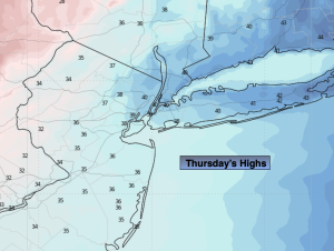
Thursday:
Becoming mostly sunny, breezy and turning colder. Highs around 40º. Temperatures will fall a bit during the afternoon. West winds at 15-25mph with gusts to 30mph.
Tonight:
Clear, breezy and colder. Lows in the lower to mid 20s in the City, the teens inland. West winds at 15-25mph with gusts to 30mph.
Friday:
Mostly sunny, breezy and cold. Highs in the lower to mid 30s.
Saturday:
Mostly cloudy with areas of light snow and rain. Highs around 40º.
Sunday:
Mostly cloudy. Highs in the mid 30s.
MLK Day:
Mostly sunny, breezy and cold. Highs in the lower to mid 30s.