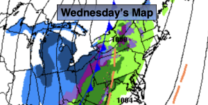
Synopsis:
Wednesday will feature more clouds. A few showers are possible as a cold front heads toward the region. It’ll be mild.
Low pressure will develop along that frontal boundary tonight and Thursday. This storm will form to far North and East to significantly affect our weather. Showers of rain and snow are likely tonight into early Thursday morning. No accumulation is expected at this time. The sun will return Thursday during the morning. It’ll turn windy and cold.
Friday will be near freezing for highs despite plenty of sun.
More clouds than sun is expected on Saturday as a weak front slows down over the region. Readings will be more seasonable. Sunday will be much colder with a mix of sun and clouds as Canadian air filters in.
Stay tuned.
Keep it here for a no nonsense, no hype forecast…
Wednesday:
Mostly cloudy. A few showers are possible. Highs in the upper 40s to around 50º. South winds at 5-10mph.
Tonight:
Scattered showers, possibly turning to snow showers by morning. Lows in the 30s throughout. South winds at 5-10mph.
Thursday:
A morning flurry, otherwise mostly sunny, windy and turning colder. Highs in the 30s.
Friday:
Mostly sunny, breezy and cold. Highs in the lower 30s.
Saturday:
Partly sunny. Highs in the lower 40s.
Sunday:
Sun and clouds. Colder. Highs in the lower 30s.