Synopsis:
High pressure over the Southeast will influence our weather today. Sunny skies and pleasant readings are expected.
Wednesday will feature more clouds. A few showers are possible as a frontal boundary parallels the coast.
Low pressure will develop along that frontal boundary Wednesday night and Thursday. This storm will form to far North and East to significantly affect our weather. Showers of rain and snow are likely into early Thursday morning. No accumulation is expected at this time. The sun will return Thursday during the late morning. It’ll turn windy and cold.
Friday will be near freezing for highs despite plenty of sun.
More clouds than sun is expected on Saturday as a weak front slows down over the region. Readings will be more seasonable.
Stay tuned.
Keep it here for a no nonsense, no hype forecast…
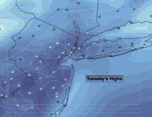
Tuesday:
Mostly sunny. Highs in the mid 40s. Southwest to South winds at 5-10mph.
Tonight:
Becoming mostly cloudy. Lows around 40º in the City, near freezing inland. Southwest winds at 5-10mph.
Wednesday:
Mostly cloudy. A few showers are possible. Highs in the upper 40s.
Thursday:
A morning flurry, otherwise mostly sunny, windy and turning colder. Highs around 40º then falling during the afternoon.
Friday:
Mostly sunny, breezy and cold. Highs in the lower 30s.
Saturday:
Partly sunny. Highs in the lower 40s.