Synopsis:
The start of the week will be bright with tolerable temperatures. High pressure over the Southeast will influence our weather through Tuesday.
Wednesday will feature more clouds. A few showers are possible as a frontal boundary parallels the coast.
Low pressure will develop along that frontal boundary Thursday. A few showers are possible with a bit of wet snow mixing in inland. Many questions need to be answered about this developing area of low pressure. How close is it to our area and how quick will it be moving? At this time, there’s a low potential of some light snow Thursday night. The latest computer guidance has the storm developing too far North for significant effects.
Friday will be cold and sunny behind the departing low.
Stay tuned.
Keep it here for a no nonsense, no hype forecast…
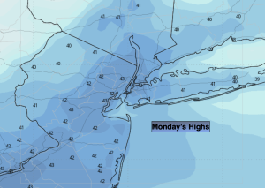
Monday:
Mostly sunny. Breezy. Highs in the lower 40s. West winds at 10-20mph with gusts to 25mph.
Tonight:
Mostly clear. Lows in the mid 30s in the City, the 20s inland. West winds diminishing to 5-10mph.
Tuesday:
Partly sunny. Highs in the mid 40s.
Wednesday:
More cloudy. A few showers are possible. Highs in the mid 40s.
Thursday:
Mostly cloudy. Some rain, mix late. Highs around 40º.
Friday:
Mostly sunny, breezy and cold. Highs in the lower to mid 30s.