Synopsis:
Today will be the better half of the weekend with the sun finally returning. It’ll become breezy with readings still above average.
It’ll turn more seasonable on Monday with the flow coming out of Canada. Readings will be near the average high of the upper 30s.
Tuesday and Wednesday will be pleasant with high pressure in control.
Looking down the pike, we’ll be watching for the development of low pressure somewhere along or off the East coast during the late week timeframe. At this time Thursday forecast is calling for a low potential of some rain possibly changing to wet snow late day and at night.
Stay tuned.
Keep it here for a no nonsense, no hype forecast…
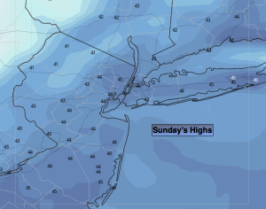
Sunday:
Partly sunny. Breezy. Highs in the mid 40s. West to Northwest winds at 10-20mph with gusts to 25mph.
Tonight:
Becoming mostly clear. Windy. Lows around 30º in the City, the 20 inland. West to Northwest winds at 15-25mph with gusts to 35mph.
Monday:
Mostly sunny. Seasonable. Highs near 40º.
Tuesday:
Partly sunny. Highs in the mid 40s.
Wednesday:
More clouds than sun. Highs in the mid 40s.
Thursday:
Mostly cloudy. Potential rain, mix late. Highs in the upper 30s.