Synopsis:
Milder temperatures will be with us through the weekend.
High pressure over the region will dominate our weather today. A mix of sun and clouds is expected along with above average readings.
Friday will feature a warm front approaching. Rain will develop later in the morning and continue on and off into Saturday as a series of fronts affect the region.
Sunday will be the better half of the weekend with the sun finally returning.
It’ll turn more seasonable on Monday with the flow coming out of Canada. Readings will be near the average high of the upper 30s.
Stay tuned.
Keep it here for a no nonsense, no hype forecast…
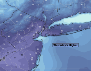
Thursday:
Sun and clouds. Highs near 50º. Northwest winds at 5-10mph
Tonight:
Partly cloudy. Lows around 40º in the City, the mid and upper 20s inland. Southeast winds less than 5mph.
Friday:
Rain developing. Mild. Highs in the lower 50s.
Saturday:
On and off rain. Highs in the upper 40s.
Sunday:
Partly sunny. Breezy. Highs near 50º.
Monday:
Mostly sunny. Seasonable. Highs near 40º.