Synopsis:
A warm front will be to our South Monday and Tuesday. This will result in more clouds than sun. Scattered flurries are possible today. Temperatures will be just above freezing today with highs on Tuesday finally getting above average. The average high is in the upper 30s.
Milder temperatures will be with us mid to late week as high pressure eventually moves off the East coast through Friday. Bright skies are expected Wednesday and Thursday. Friday will feature a warm front approaching. Showers are possible.
Our January thaw has arrived!
Stay tuned.
Keep it here for a no nonsense, no hype forecast…
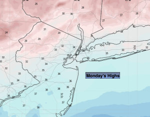
Monday:
Mostly cloudy. Scattered flurries possible. Highs in the lower to mid 30s. Southeast winds at 5mph.
Tonight:
Mostly cloudy. Lows in the lower to mid 30s in the City, the 20s inland. Light winds.
Tuesday:
Mostly cloudy. Highs in the lower 40s.
Wednesday:
Partly sunny. Milder. Highs in the mid 40s.
Thursday:
Sunny. Highs in the upper 40s.
Friday:
Mostly cloudy. Showers likely. Mild. Highs in the lower 50s.