Synopsis:
The wind will be the main story today. Gusts up to 45mph can be expected. It’ll be much colder Tuesday through New Year’s Day as Canadian air settles upon the region. Snow showers are possible as we head to the stroke of midnight New Year’s Eve.
Friday and Saturday will feature a slight rebound in temperatures as the core of the cold airmass loosens its grip. Mainly sunny skies are expected.
Stay tuned.
Keep it here for a no nonsense, no hype forecast…
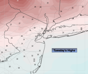
Tuesday:
Partly sunny, windy and cold. Highs in the lower 30s. West winds at 15-30mph with gusts to 45mph.
Tonight:
Partly cloudy, breezy and cold. Lows in the 20s. West winds at 10-20mph.
Wednesday:
Becoming mostly cloudy. Breezy and cold. Snow showers possible during the evening. Highs in the lower to mid 30s.
New Year’s Day:
Mostly sunny. Highs around 30º.
Friday:
Partly sunny. Highs in the lower 30s.
Saturday:
Mostly sunny. Highs in the mid 30s.