Synopsis:
A cold front will swing through with scattered showers through midday. It’ll start off mild with highs in the 40s and lower 50s. Temperatures will fall during the afternoon as the cold air filters in. The drop in temperatures will be accompanied by a strong Northwest wind gusting up to 45mph.
It’ll be much colder Tuesday through New Year’s Day as Canadian air settles upon the region. A few flurries or snow showers are possible as we head to the stroke of midnight New Year’s Eve.
Stay tuned.
Keep it here for a no nonsense, no hype forecast…
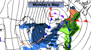
Monday:
Morning showers, otherwise partly sunny, windy and turning colder. Early highs in the 40s and lower 50s. Temperatures falling through the 40s and into the 30s during the mid to late afternoon. Southwest to West winds at 15-30mph with gusts to 45mph.
Tonight:
Mostly clear, windy and cold. Lows in the 20s. West winds at 15-30mph with gusts to 45mph.
Tuesday:
Partly sunny, windy and cold. Highs in the mid 30s.
Wednesday:
Partly sunny, breezy and cold. Highs in the mid 30s.
New Year’s Day:
Mostly sunny. Highs in the lower 30s.
Friday:
Partly sunny. Highs in the lower 30s.