Synopsis:
Any light precipitation this morning will taper off. Skies will remain Mostly cloudy. The snow forecast for much of the region was a bust. I will admit that. Warm air aloft gave much of the area from the City and into NJ more sleet than anything else. Untreated surfaces are very icy. Please use caution today.
Skies will clear tonight. It’ll be cold with high pressure ridging in from the North.
A warm front will approach Sunday. The day will start off dry with some sun . Scattered showers are possible later in the day and evening. Seasonable readings are expected (around 40º).
Monday morning a cold front will swing through with scattered showers through midday. It’ll start off mild with highs near 50º. Temperatures will fall during the afternoon as the cold air filters in. The drop in temperatures will be accompanied by a strong Northwest wind.
We’ll be in the freezer Tuesday with Canadian air upon the region under a partly sunny sky. The chill will remain into midweek.
Stay tuned.
Keep it here for a no nonsense, no hype forecast…
Saturday:
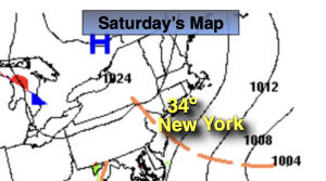
AM light snow/mix tapers off by mid morning. Remaining mostly cloudy. Highs in the lower to mid 30s. Northeast to North 10-15mph.
Tonight:
Mostly clear and cold. Lows in the mid to upper 20s in the City, the single digits and teens inland. Northwest winds at 5mph.
Sunday:
Sun to clouds. Highs in the lower 40s.
Monday:
Morning showers, otherwise partly sunny, windy and turning colder. Early highs around 50º. Temperatures falling through the 40s during the afternoon.
Tuesday:
Partly sunny, windy and cold. Highs around freezing.
Wednesday:
Partly sunny, windy and cold. Highs in the mid 30s.