Synopsis:
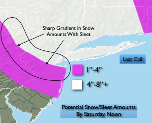
Low pressure will move from the Upper Ohio Valley to off the Mid-Atlantic coast through Saturday. Winter Storm Warnings and advisories has been issued for this timeframe. The latest computer guidance continues the scenario with high pressure over Southeastern Canada supplying enough cold air for accumulating snow and sleet tonight. A few hours of heavy snow is likely in the NYC vicinity later this evening and early tonight. 1″/hr snow rates are possible during this time. A mix is likely over central and Southern areas. Where sleet maybe the dominate precipitation type. Questions that need to be answered. Where does the transition zone align. This will determine where the sharp gradient in significant snow accumulation will be. The “last call” map is above. The potential for a 4″-8″+ snowfall is there for the immediate NYC vicinity with lighter amounts to the South and West.
Any precipitation on Saturday will taper off during the late morning. Skies will remain Mostly cloudy.
A cold front will approach Sunday. The day will start off dry. Scattered showers are possible later in the day.
Monday morning the front will swing through with scattered showers through midday. It’ll start off mild with highs near 50º. Temperatures will fall during the afternoon as the cold air filters. The drop in temperatures will be accompanied by a strong Northwest wind.
We’ll be in the freezer Tuesday with Canadian air upon the region under a partly sunny sky. The chill will remain into midweek.
Stay tuned.
Keep it here for a no nonsense, no hype forecast…
Tonight:
Snow/mix depending on location. Lows in the mid to upper 20s. East to Northeast winds 5-10mph increasing to 10-20mph.
Saturday:
AM light snow/mix tapers off late morning. Remaining mostly cloudy. Highs in the mid 30s.
Sunday:
Mostly cloudy. Late day shower possible. Highs in the lower 40s.
Monday:
Morning showers, otherwise partly sunny, windy and turning colder. Early highs around 50º. Temperatures falling through the 40s during the afternoon.
Tuesday:
Partly sunny, windy and cold. Highs around freezing.
Wednesday:
Partly sunny, windy and cold. Highs in the mid 30s.